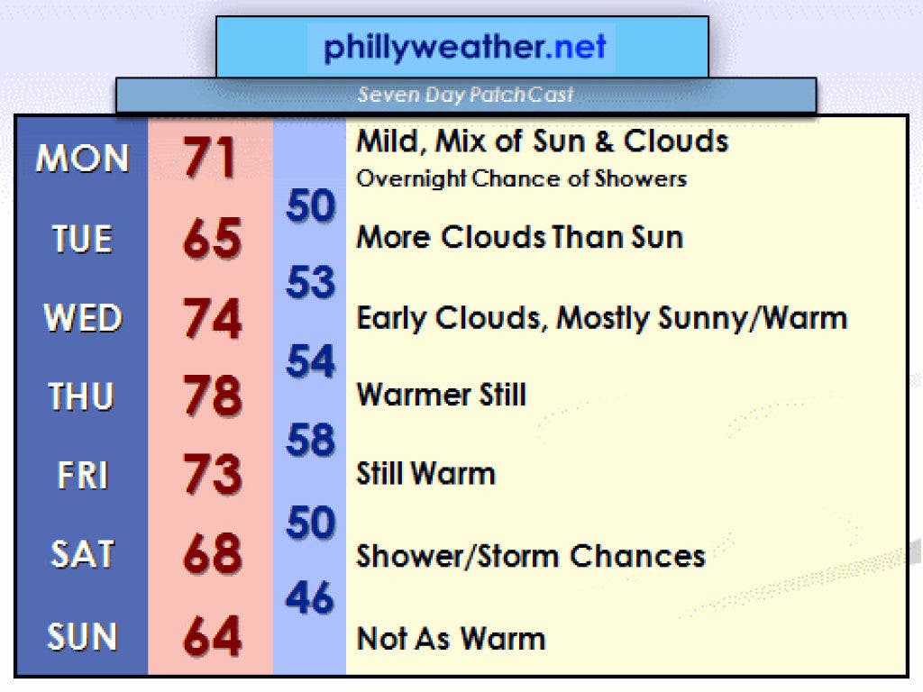
May — I mean March — continues on a mostly warm note. Yeah, we've had a couple of days where low clouds and fog have wrecked temperature forecasts and we didn't get as warm as hoped or hyped. Thanks to the natural air conditioner known as the Atlantic Ocean (where water temperatures are around 50 degrees) and a high pressure center to the east, a weak southeasterly flow has been the culprit in bringing a couple of mornings of low clouds and fog. This resulted in mild — but not as warm — temperatures on a couple of occasions last week. However, we did break 70 three times.
We will have to contend with low clouds and fog on a few mornings this week. The best chances for persistent cloud cover and temperature forecast busts are Tuesday, as a weak disturbance and this high pressure system position themselves perfectly to throw Atlantic air into the region. We could see some showers and perhaps a thunderstorm on Monday night into Tuesday morning as well. This disturbance fizzles out over the course of Tuesday and the high pressure center gradually nudges a bit to our south, positioning itself near Cape Hatteras. This will result in a much more optimal setup for warmth later on this week.
The question becomes whether or not we will hit 80 degrees at some point. The best chances for this will be either Thursday or Friday. The forecast right now points towards Thursday. I would not be surprised if some areas flirt with 80 on Thursday afternoon. However, the stretch of mildness will gradually come to an end as the ridge of high pressure breaks down a bit and a cool front slips down from Canada. There's some uncertainty on exactly when the front slides through on Friday, but if it's a bit slower in moving through, we could approach Thursday's temperatures for a second day.
Find out what's happening in Upper Dublinwith free, real-time updates from Patch.
Another shot of thunderstorms and showers are possible on Saturday, and perhaps Sunday, while a persistent low pressure system in the Plains and Midwest finally nudges east and northeast as the ridge of high pressure wanes. Enjoy this week's warm temperatures: cooler weather is on tap for next week.
Tom Thunstrom is the editor and publisher of PhillyWeather.net. You can follow the site on Twitter – @phillywx.